A commercial slab-on-grade project along I-20 stopped dead when the excavator hit unexpected weathered shale at just three feet. The construction team had relied solely on SPT data and missed the shallow refusal layer completely. Arlington's geology doesn't read like a textbook — the Eagle Ford Shale and Woodbine sandstone formations weather unpredictably across the metroplex. An exploratory test pit provides what no drilled sample can: a continuous vertical face where bedding planes, moisture seams, and fill boundaries are visible and measurable. Our field team logs directly per ASTM D2488, collecting bulk samples and in-situ density data while the excavation stays open. For projects in East Arlington's expansive clay zones, this visual correlation proves invaluable before finalizing foundation elevations. We pair test pit observations with Atterberg limits testing to quantify the plasticity of clay layers identified in the exposed profile.
A single exploratory test pit exposes more stratigraphic detail in 30 minutes than a full day of drilling in Arlington's interbedded shale formations.
Methodology and scope
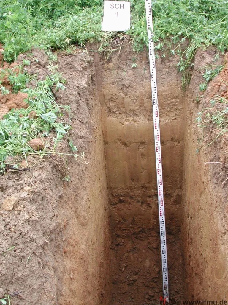
The most common mistake we see in Arlington is treating test pit backfill as an afterthought — contractors dump loose spoil back in and call it done, then wonder why the slab cracks six months later. A properly executed exploratory test pit delivers far more than a hole in the ground. Our crews excavate to target depth with a trackhoe or backhoe, trim one vertical face clean, and log stratigraphy in continuous increments using the Unified Soil Classification System. We photograph the face with scale references and collect representative disturbed and undisturbed samples at layer boundaries. The exposed profile reveals features that split-spoon samples routinely miss: thin sand seams that act as perched water conduits, desiccation cracks extending three feet down, or construction debris from old Arlington fill operations. Each log includes GPS coordinates tied to the project survey grid, so the data integrates directly into the geotechnical baseline report without reprocessing. For deep excavations near the Trinity River, we coordinate shoring requirements before the pit opens to maintain OSHA compliance throughout the sampling window.
Local geotechnical context
Our field teams operate a 20-ton trackhoe or rubber-tire backhoe depending on Arlington site access constraints — tight residential lots in the 76013 area demand the smaller machine, while open commercial sites near AT&T Stadium allow the faster trackhoe. Before the bucket touches the ground, we sweep the excavation zone with private utility locating equipment and call in a Texas 811 ticket. Arlington's older neighborhoods are laced with undocumented gas laterals and abandoned clay sewer lines that don't appear on any utility map. We maintain a spotter on the trench edge during all pit operations. The biggest hazard isn't the machinery — it's the soil itself. Type C soils dominate the region, and Arlington's summer heat can dry the upper crust of clay to a hard shell that masks soft, unstable material underneath. Every pit deeper than five feet gets stepped benching or hydraulic shoring before anyone enters. Our safety protocol follows OSHA 1926 Subpart P with no exceptions, and the site supervisor carries a calibrated gas monitor for excavations near old fill zones where organic decomposition can produce methane pockets.
Relevant standards
ASTM D2488 — Visual-manual soil description and classification, OSHA 1926 Subpart P — Excavation safety, sloping, and shoring, ASTM D420 — Site characterization for engineering purposes, IBC Chapter 18 — Foundation investigation requirements, USCS (ASTM D2487) — Soil classification for engineering
Quick answers
What does an exploratory test pit cost in Arlington?
Budget between US$480 and US$840 for a standard pit excavated to 8–10 feet depth with full logging, photography, and sampling. The range depends on access difficulty, shoring needs, and whether we leave the pit open overnight for water level observation. Deeper pits or multiple pits on the same site reduce the per-unit cost through mobilization savings.
How long does the test pit stay open before backfilling?
Most pits are logged and backfilled within one shift — typically two to three hours. If groundwater monitoring is requested, we fence and barricade the opening for a 24-hour observation period, provided soil stability and weather conditions permit safe open excavation.
Do you handle the utility locating or do we need a separate contractor?
We coordinate the Texas 811 ticket and perform a private sweep of the excavation zone with electromagnetic and ground-penetrating radar equipment before the bucket goes in. You don't need a separate locator contract for the pit footprint.